
The world's first professional night-time light remote sensing satellite - "Luojia I" was successfully launched successfully
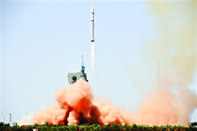
At 12:13 on June 2, 2018, China successfully launched the "Luojia I" scientific experimental satellite using the Long March II carrier rocket at the Jiuquan Satellite Launch Center in China. The satellite entered the scheduled orbit as planned and the launch mission was a complete success.
"Luojia I" satellite is the first satellite developed by Changguang Satellite Technology Co., Ltd. for Wuhan University through commercial order. It is the world's first professional night-time light remote sensing satellite, which is mainly used for night-light remote sensing and navigation augmentation technology verification. The satellite is fully inherits built on the technical foundation accomplishment of the "Jilin I" satellite, adopts an integrated design with highly integrated functions. It extensively adopts innovative technologies such as high signal-to-noise ratio high dynamic imaging, large-scale impact isolation, and self-locking of windsurfing. At the same time, the satellite adopts the configuration of mainstream remote sensing satellites such as high-precision double-satellite sensitive joint positioning, which provides guarantee for obtainingsecures high-quality remote sensing data.
The entire "Luojia I" satellite has a total weight of onlyonly weighs 20kg. It carries a wide-view high-sensitivity night-time light remote sensing camera with 130m resolution and 260km wide-view imaging capability, which will provide data for research on macroeconomy analysis based on night-time light remote sensing.. At the same time, the satellite is equipped with navigation augmentation scientific test load, and can carry out tests such as improving the positioning accuracy of the Beidou navigation system.
In the follow-upnear future, Changguang Satellite Technology Co., Ltd. will cooperate with Wuhan University to carry out satellite on-orbit test, conduct “one picture” for nationwide remote sensing integration and Beidou navigation augmentation test, fully combine mature satellite R&D technology with university academic advantages, and jointly conduct scientific research and technological innovation.


