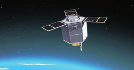
China's first satellite developed at a provincial level and named after the province – Jilin No.1

The "Jilin No. 1" satellite is China's first self-developed commercial remote sensing satellite group. It not only "stands high", "sees" far, but also has "sharp eyes". On November 21 last year, "Jilin No. 1" successfully launched three video satellites via the capacity of “one rocket for three satellites”. After only nine hours, they sent the first picture back from a height of 500,000 above the earth. How good is "Jilin No. 1"? Recently, the reporter visited Changguang Satellite Technology Co., Ltd., where the satellite research team is located.
"Jilin No. 1", the "eyes of the sky", mainly provides remote sensing data and product services for government departments and industry users. At present, "Jilin No. 1" has eight satellites in orbit, and the three newly launched satellites are being commissioned. Ten more satellites will be launched this year, which means that "Jilin No. 1" has entered a dense launch period. According to the plan, by 2020, there will be 60 satellites in orbit sent by "Jilin No. 1".
It is said that in ten years, in the field of civil satellites, the world's best optical remote sensing satellite will be born in China: "We will be the only country to have such a satellite in the world. I think that after a decade or so, our Changguang satellite should be confident enough to develop such a satellite."
Jilin No. 1 is also the first satellite developed at provincial level and named after the province in China.
Changguang Satellite Technology Co., Ltd. was established on December 1, 2014. It is the first commercial remote sensing satellite company in China. The "Jilin No. 1" satellite that captured this exciting picture was independently developed by the company in 2015.
According to the website of Changguang Satellite, on October 7, 2015, the “Jilin No.1” group star independently developed by the company was successfully launched, which pioneered the application of commercial satellites in China, and also created a history of successfulthe success of launching four-star satellitelaunch in one satellite at one time developed by a single team. “Jilin No.1” is mainly for civilian use. It is a geodetic observation satellite that can provide people with more accurate geographic information, as well as disaster investigation, food production assessment, and communication.
According to www.guancha.cn, the team also released a clear picture of the US military shipyard photographed by the commercial a earth observation satellite last year, in which US aircraft carriers and destroyers are clearly visible.
This time, the satellite photo was taken at Nellis Air Force Base (Nellis AFB) in Nevada, USA, which is 13 kilometers northeast of the famous casino Las Vegas CBD area and covers an area of 4,600 hectares. As a facility in the Air Combat Command, Nellis Air Force Base is home to the US Air Force Air Operations Center and is a major provider of training for US and foreign military aircraft teams.
The F-15, F-16 and A-10 fighters can be seen clearly in the photo, as well as the command post, training center, hangar and all flight tracks. Dozens of aircraft can be seen except for those in the hangar.


